


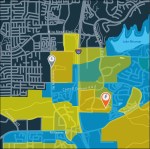
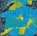
Bay Area Rapid Transit Solar Planning, Optimization, and Placement
2013 – 2014
In partnership with Arup I mapped and optimized locations to place solar panels given solar resource, utilizable space, and cost restrictions. Key insights on locations with the highest energy demand, viable transmission lines, and the highest value solar resource were delivered as part of this year long effort. I utilized GIS, NREL PVWatts Solar Modeling, SQL Database Language, and spatial analysis to identify key regions along BART owned property to place solar panels to power local transport.
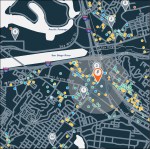
Modeled and Mapped Optimal Locations for Electric Vehicle Chargers across the San Joaquin Valley – December 2013
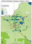


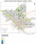
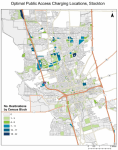


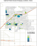

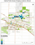


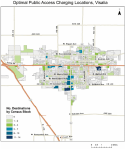
As part of the Plugin Electric Vehicle Readiness Program for the state of California, created a python model that calls Google Maps API for the locations of conveniences and amenities. Other spatial data employed in the model include driving range, employment locations, traffic data from NHTSA, and walking distance to optimally place electric vehicle chargers throughout California.
Link: San Diego Plugin Electric Vehicle Analysis
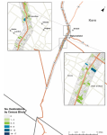
Modeled Optimal Locations to Park and Charge Electric Vehicles in San Diego County –October 2013
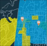


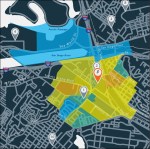


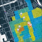


Locations were chosen based on walking distance of passenger and nearby conveniences and workplaces using multiple spatial layers.
Modeled a Two Hundred Electric Vehicle Fleet and Spontaneous Energy Demand to meet Ridership based on Randomized Tourist and Employee trips
July 2013
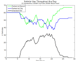


Utilizing Matlab, Python, GIS, and APIs created an electric vehicle transportation model that accounts for passengers on the island, destinations, battery constraints, available solar insolation, EV charging, and other parameters to replace the existing fleet of buses and diesel generators on the Hawaiian Island of Lanai.
Remote Sensing – Function Automation – Water Quality Sampling
United States Geological Survey 2010 – 2013
Professional Reference: Dr. Ken Belitz – Project Chief
Ground Water Quality Monitoring and Assessment (GAMA)
kbelitz@ usgs.gov
I had the privilege of automating data analysis at the USGS analyzing satellite imagery, and creating programming scripts with the purpose of automating thousands of well calculations to detect spatial trends in ground water quality.
Remote Sensing – My work in remote sensing is a product of excellent mentorship under Ken Belitz and Tyler Johnson who have laid the groundwork for a novel way to remotely monitor rates of urban irrigating (e.g. lawns) using satellite imagery. I am expanding on this work and focusing on using MODIS satellite imagery to enhance the temporal frequency of urban irrigation assessments.
Calculation Automation – For the past three summers I have created Excel Visual Basic programs for the Ground Water Quality Monitoring and Assessment program to allow for quick batch calculations enabling more USGS employees to analyze wells more efficiently. These include water depth, quality control, well prospecting, and well logging programs.
